Free tools Windows power users keep installed
One-click scans. No signup required.
Outdated Drivers Are Slowing You Down
One free scan finds every outdated or missing driver and matches the right update for your exact hardware.Free scan · exact hardware matchWindows Errors? Fix Them Before They Spread
Repair common Windows errors and clear accumulated junk for a smoother, more stable PC - no reinstall needed.Free scan · no reinstallThatPainter is reader-supported. When you buy through links on our site, we may earn an affiliate commission. Learn More
For a quick blank Andorra map to label, use Wikimedia Commons’ Blank map of parishes of Andorra SVG. For authoritative layers, detailed topography or GIS/CAD work, use the Government of Andorra’s IDE Andorra map portal and its separate official cartography service. These resources are not interchangeable: choose according to whether you need a simple outline, named places or precise mapping data.
Choose the Andorra map that fits your task
| Your need | Best starting point | What it offers |
|---|---|---|
| Blank map of Andorra for labeling | Wikimedia Commons blank parish SVG | A file explicitly described as a blank map of Andorra’s parishes; the original file format is SVG. |
| Interactive exploration or custom layers | IDE Andorra | A government map portal with map layers and download options, including KML, GML, GeoJSON, GPX, DXF and SHP. |
| GIS, CAD or detailed topographic work | Govern d’Andorra cartography service | The official 1:5,000 topographic base, with SHP, DXF, DGN v8 and GeoTIFF formats and published technical specifications. |
| Visitor orientation and locality names | Visit Andorra 2025 guide and map | A tourism-oriented map labeling parishes and numerous localities. |
When comparing options, check the purpose, boundary detail and authority, file format, scale or precision, and whether place labels are included. Check the individual file or download conditions before republishing: available source information does not establish reuse terms for every map output.
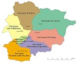
Blank Andorra outline map with parishes
The Commons SVG is the most direct choice for a blank parish map you want to view or label. Andorra has seven parishes, named in the 2025 English visitor guide as Canillo, Encamp, Ordino, La Massana, Andorra la Vella, Sant Julià de Lòria and Escaldes-Engordany.
#1 Best Overall

- 💖【Selected Materials】◆100% High-Quality Canvas Printing, Using Environmentally Friendly Canvas That Fully Meets The Standards, Embellish Your Life And Workplace Under The Premise Of Ensuring The Safety Of You And Your Family.
- 💖【Perfect Decoration】◆It Is The Best Choice Whether To Decorate Any Space, Or As A Holiday Gift Or Souvenir To Family, Friends, Classmates And Colleagues.
- 💖【Easy To Install】◆Each Of Our Canvases Is Equipped With A Solid Wood Frame For You To Use, You Just Hang Them On The Wall With Nails, Which Is Convenient And Simple, And Can Make Your Environment More Interesting And Warm.
- 💖【Quality Assurance】◆Every Product Will Be Strictly Screened By Us To Ensure Your High-Quality Shopping Experience, Your Satisfaction Is Our Consistent Pursuit.
- 💖【After-Sales Service】◆There Is No Doubt That If You Are Not Satisfied With The Shopping Experience, You Can Always Contact Us By Email,We Are Willing To Refund Or Exchange For You,If You Are Willing To Share Some Photos With Us, We Would Be Very Grateful.
A simplified outline is useful for general reference, but the Commons file page does not establish that every boundary is suitable for legal, cadastral or survey use. A separate Commons location-map page warns that its dotted parish boundaries are estimated from very small-scale reference maps; do not treat that caveat as a specification for every Commons map, or assume a simple outline is survey-grade.
Independent reader supportYour contribution helps us test, update, and keep practical guides available for everyone.Use the official map portal for layers and downloads
The IDE Andorra portal is the better starting point when you need to explore map layers or obtain data rather than download one static blank map. Its listed download choices include KML, GML, GeoJSON, GPX, DXF and SHP. A separate government viewer advertises print preview and GeoPDF output: Geoportal viewer.
These portal options should not be confused with the specifications for the separate official 1:5,000 topographic base. Confirm the current metadata and conditions for the particular layer or file you download.
Rank #2
- Frame Ready: Your unframed poster ships crease-free, rolled in a sturdy mailing tube. Poster fits easy-to-find standard size frames saving on custom framing.
- Heat sealed Lamination for years of protection. Sharp and Crisp images with stunning color and vibrancy. Fade and Tear Resistant.
- Printed on high quality 36lb photo matte paper. Heat sealed Lamination for years of protection.
- Perfect Decoration for Classroom, living room, bedroom, office,lobby, waiting room, lounge, office, hall, bar, home
When to use the 1:5,000 official topographic base
The Govern d’Andorra cartography service describes its BTA 5M v1.1 as detailed GIS cartography, not simply a country outline. The service lists a 1:5,000 scale, 5 m contour intervals, 25 m labeled major contours, 1 m planimetric precision and 1.5 m altimetric precision. It offers the base in SHP, DXF, DGN v8 and GeoTIFF formats. The service presents the dataset as a response to demand for GIS cartography.
Recommended Free Tools
The cartography page does not state a publication year for these specifications. They apply to the BTA 5M v1.1 described there; do not assume they apply to every map or dataset in the government portal. Check the selected file’s metadata and terms at download time.
Quick Recap
Check boundaries and reuse terms before publishing
- Use the blank parish SVG for simple labeling or reference, not as proof of legal or cadastral boundaries.
- For technical work, use official data appropriate to the task and inspect the metadata for the specific download.
- Before republishing a map, verify the reuse terms attached to that file or download; there is no established blanket reuse claim for all outputs.

Product prices and availability are accurate as of the date/time indicated and are subject to change. Any price and availability information displayed on Amazon at the time of purchase will apply.